Back to results 204m² Vacant Land in Rikuzentakata City, Iwate Prefecture
Marked sold 6 days ago

Know someone who would love this? Gift them a subscription

Negotiable

Takata-cho Nakagawara, Rikuzentakata City, Iwate Prefecture

岩手県 陸前高田市 高田町字中川原

Listing No Longer Available

Sign in to save properties

Sold Land Akiya Bank Waterfront Quiet Area

Unlock the full description with a free trial

Includes AI translation, hazard data, cost estimates & nearby amenities

3 days free · cancel anytime

Start Free Trial

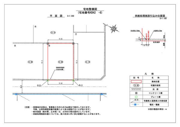
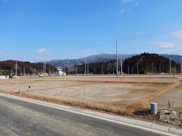
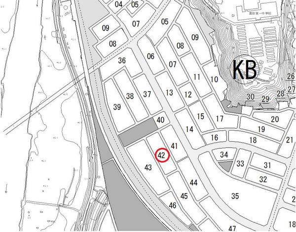
Located in Takata-cho Nakagawara, Rikuzentakata City, Iwate Prefecture, this vacant land property presents an excellent opportunity for development. The 204-square-meter plot is situated in a Type 1 residential zone, offering a building coverage ratio of 60% and a floor area ratio of 200%. The property is currently undergoing land readjustment project and has been designated as a temporary replotting area (KB42 Block, Plot 8).

Rikuzentakata City enjoys a relatively mild climate throughout the year thanks to its oceanfront location in southeastern Iwate. The area has seen significant redevelopment since the 2011 tsunami, including seawall construction, land elevation projects, and the relocation of city facilities. The nearby Miracle Pine memorial and the recently opened Takata-Matsubara Road Station have become popular attractions, contributing to the area's revival.

The property is accessible via the JR Ofunato Line's Rikuzentakata Station (BRT), making it convenient for daily commuting. This area has attracted numerous new residents and entrepreneurs, creating a supportive community atmosphere that welcomes fresh perspectives and innovative ventures.

This description was AI-generated from the original Japanese listing and may contain inaccuracies. Please verify details with the source listing.

Summary

Land size: 204 / 2,196sqft

Short-Term Rental (Minpaku)

Transport

NRT

Narita International Airport — 377 km away

Nearby Konbini

Lawson Lawson — 16 min walk

Internet Connectivity

Natural Hazard Assessment

Flood Risk Low Risk
Landslide Risk Moderate
Tsunami Risk Low Risk
Earthquake Hazard Moderate

Unlock hazard data with a free trial

Flood, landslide, tsunami & earthquake risk for this property

3 days free · cancel anytime

Start Free Trial

Map & Street View

Map loading...

Location Accuracy Notice: Although we try to make the map accurate with coordinates or address details provided, the location data is provided by the agent. This map data should be used as reference for the surrounding area foremost.

Location Type Beds Price Land House View

* Sold properties shown for price comparison only. Prices reflect historical sale data.

Location Type Beds Rent/Month Land House View

* Rental prices shown are monthly rates. Contact property owner for current availability.