Back to results Residential Land for Sale in Tamano City, Okayama - 159.44 sqm

Needs Verification

This listing hasn't been verified recently. Tap to request a priority check!

Know someone who would love this? Gift them a subscription

¥3,100,000

Okutama 1-chome 16, Tamano City, Okayama Prefecture

岡山県玉野市奥玉1丁目16

Sign in to save properties

Work with our partners to help you search, evaluate, and purchase property in Japan.

Book a Consultation
Buy Land Corner Lot Gas Heating/Cooking Septic System

Full description available to subscribers

Includes AI translation, hazard data, cost estimates & nearby amenities

Start Free Trial

Land for Sale in Tamano City, Okayama Prefecture

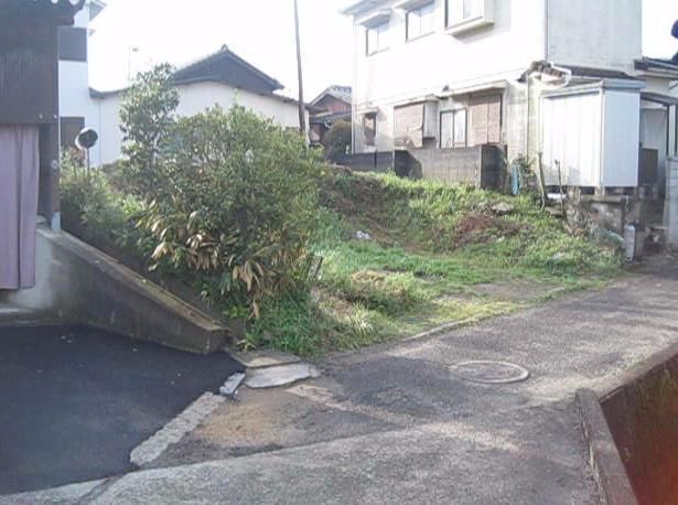
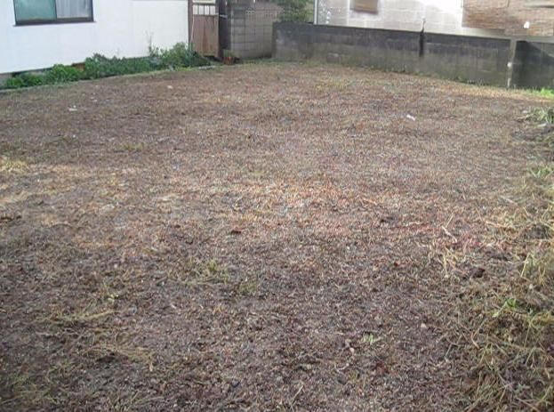
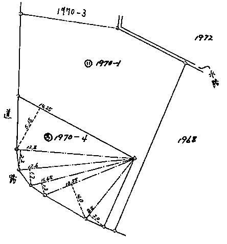
This residential land plot is located in the Okutama 1-chome area of Tamano City, Okayama Prefecture. The property is a vacant lot with a total land area of 159.44 square meters (approximately 48.23 tsubo). It is situated in a Category I Exclusive Residential Zone within a City Planning Area, with a building-to-land ratio of 60% and a floor area ratio of 160%. The land is designated for residential use and is currently vacant, ready for immediate handover.

Key property features and agent notes include essential utilities: Propane gas, water supply, sewerage, and electricity are all available. The road access details are specified: the property fronts two roads (excluding corner lots). To the west, there is a 2.3-meter wide public road with an 8.5-meter frontage, which is paved. To the south, there is a 1-meter wide public road with a 1-meter frontage, also paved. A critical special note is that a setback of 15 square meters is required.

The location offers convenient access, with the Fujisakicho bus stop approximately 300 meters away, a 4-minute walk. The area of Tamano City is part of the Seto Inland Sea region, known for its beautiful coastline and maritime history. An interesting local fact is that Tamano City is home to the famous Seto Ohashi Bridge, one of the world's longest two-tiered bridge systems connecting Honshu to Shikoku. The closest major landmark is the scenic Shikoku Karst, a highland area known for its unique limestone landscape, accessible from the city.

This description was AI-generated from the original Japanese listing and may contain inaccuracies. Please verify details with the source listing.

Summary

Land size: 159 / 1,716sqft

Short-Term Rental (Minpaku)

Transport

KIX

Kansai International Airport — 121 km away

Nearest Konbini

circle_k Circle K — 14 min walk

Internet Connectivity

Natural Hazard Assessment

Flood Risk Low Risk
Landslide Risk Moderate
Tsunami Risk Low Risk
Earthquake Hazard Moderate

Natural Hazard Assessment

Flood, landslide, tsunami & earthquake risk data for this property

Start Free Trial

Purchase Cost & Tax Estimates

Agent fees, acquisition tax, registration costs & annual property tax

Airbnb Revenue Estimate

Projected nightly rate, occupancy & net income for this property

Investment ROI

Annual yield, break-even timeline & 10-year return projection

Map & Street View

Map loading...

Location Accuracy Notice: Although we try to make the map accurate with coordinates or address details provided, the location data is provided by the agent. This map data should be used as reference for the surrounding area foremost.

Location Type Beds Price Land House View

* Sold properties shown for price comparison only. Prices reflect historical sale data.

Location Type Beds Rent/Month Land House View

* Rental prices shown are monthly rates. Contact property owner for current availability.