Back to results Land for Sale in Tachibanadai, Yokohama - 209 sqm Plot

Needs Verification

This listing hasn't been verified recently. Tap to request a priority check!

Know someone who would love this? Gift them a subscription

¥25,000,000

Tachibanadai 1-chome, Aoba Ward, Yokohama, Kanagawa Prefecture

神奈川県横浜市青葉区たちばな台1丁目

Sign in to save properties

Buy Land Needs Renovation Rural Suburban Quiet Area

Unlock the full description with a free trial

Includes AI translation, hazard data, cost estimates & nearby amenities

3 days free · cancel anytime

Start Free Trial

Land for Sale in Yokohama's Tachibanadai 1-chome, Aoba Ward

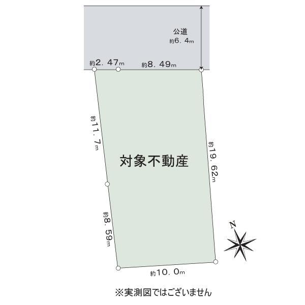
This 209.00 sqm (approximately 63.22 tsubo) plot of land is available for purchase in the residential area of Tachibanadai 1-chome, Aoba Ward, Yokohama, Kanagawa Prefecture. The property is conveniently located, with access via a 5-minute bus ride from the Tokyu Den-en-toshi Line's "Aoba-dai" station, followed by a 5-minute walk from the "Mitakedai Elementary School" bus stop.

The land is situated within a City Planning Area designated as an Urbanization Promotion Area. The zoning is Category I Low-Rise Exclusive Residential District, with a building-to-land ratio of 50% and a floor area ratio of 80%. The site is subject to the Building Standards Act Article 22 zone regulations. Specific conditions include a required front setback of 1 meter from the road, a minimum lot area of 125 sqm, a height restriction of 10 meters, and shadow regulations of 1.5m/3 hours/2 hours. The plot is also within a land readjustment project regulation zone.

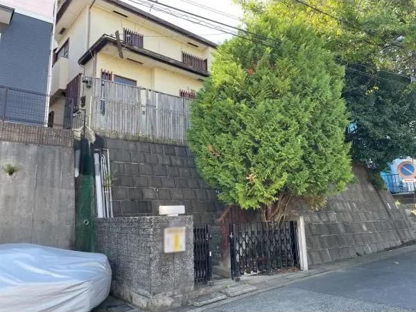
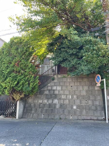
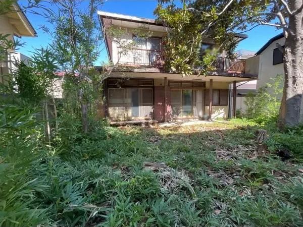
A key feature of this property is the presence of an existing old house. The structure is a two-story wooden house with a slate and galvanized steel sheet roof. The floor area is 65.54 sqm on the first floor and 42.72 sqm on the second floor. It is important to note that there is a retaining wall on the premises. Should you plan to build or rebuild, it may be necessary to construct a new retaining wall or reinforce the existing one, which will incur additional costs.

The road access details are for a single-sided road to the north, which is a public road with a width of 6.4 meters. The land shape is irregular, and the terrain is sloped. The current land classification is forest land. There are no specific building conditions attached to the sale, and the timing for handover is negotiable.

This description was AI-generated from the original Japanese listing and may contain inaccuracies. Please verify details with the source listing.

Summary

Land size: 209 / 2,250sqft
House size: 108 / 1,165sqft

Short-Term Rental (Minpaku)

Transport

Nearest Konbini

lawson Lawson — 5 min walk

Internet Connectivity

Natural Hazard Assessment

Flood Risk Low Risk
Landslide Risk Moderate
Tsunami Risk Low Risk
Earthquake Hazard Moderate

Unlock hazard data with a free trial

Flood, landslide, tsunami & earthquake risk for this property

3 days free · cancel anytime

Start Free Trial

Purchase Cost & Tax Estimates

Agent fees, acquisition tax, registration costs & annual property tax

Airbnb Revenue Estimate

Projected nightly rate, occupancy & net income for this property

Investment ROI

Annual yield, break-even timeline & 10-year return projection

Map & Street View

Map loading...

Location Accuracy Notice: Although we try to make the map accurate with coordinates or address details provided, the location data is provided by the agent. This map data should be used as reference for the surrounding area foremost.

Location Type Beds Price Land House View

* Sold properties shown for price comparison only. Prices reflect historical sale data.

Location Type Beds Rent/Month Land House View

* Rental prices shown are monthly rates. Contact property owner for current availability.