Post-Purchase Potential: A Spacious Property with Diverse Land Parcels in Fukushima's Oguni Town
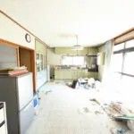
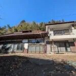
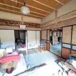
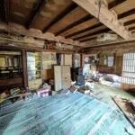
According to agent notes, the property includes other ancillary buildings: a shed and a separate two-story wooden tile-roofed building (42.64㎡ per floor). Apart from this two-story structure, demolition of the other buildings is advised. The land itself is extensive and varied, classified as residential, mountain forest, field, and paddy field, with a total area of 21,753.07㎡ (approximately 6,580 tsubo). The terrain includes both flat and sloped areas. Notably, the plot includes separate, non-contiguous parcels of land (tobichi). The flatter sections of these could potentially be repurposed for energy-related uses. The sale of only a portion of the total land area is open for discussion.
The property is situated along National Route 349, which runs north-south through the Abukuma Highlands. Utilities include electricity, a private well, and an individual septic tank. It is outside city planning zones. Important legal notes indicate it is within a sediment disaster warning zone and special sediment disaster warning zone. It is also subject to the Agricultural Land Law, Agricultural Promotion Area Law (blue zone), Forest Law, National Land Use Planning Law, Fukushima Prefecture Landscape Ordinance, and Fukushima Prefecture Building Standards Act Enforcement Ordinance (cliff ordinance).
Oguni Town is famous for the legend of the birth of the Heian-era poet Ono no Komachi and is located in the central part of the Abukuma Highlands, known for its rich natural environment. The area is gaining attention as a candidate for relocation, with easy road access via the Banetsu Expressway and the Abukuma Kogen Road. A notable landmark in the region is the stunning Abukuma Cave, a vast limestone cavern known for its spectacular formations, located within a reasonable driving distance.