Back to results Large Development Land in Rikuzentakata - 2,489m² Vacant Plot

Verified Listing

This property was checked recently and confirmed to still be available. Tap for details.

Verified Listing

This property has been verified in the last month. Our system regularly checks listings to ensure they are still available.

Last verified: April 20, 2026

Know someone who would love this? Gift them a subscription

Negotiable

Takata-cho Oishioki, Rikuzentakata City, Iwate Prefecture

岩手県 陸前高田市 高田町字大石沖

Sign in to save properties

Rent Land Waterfront Quiet Area

Unlock the full description with a free trial

Includes AI translation, hazard data, cost estimates & nearby amenities

3 days free · cancel anytime

Start Free Trial

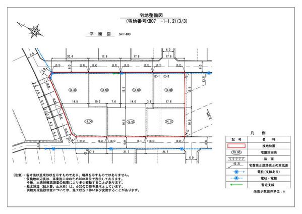
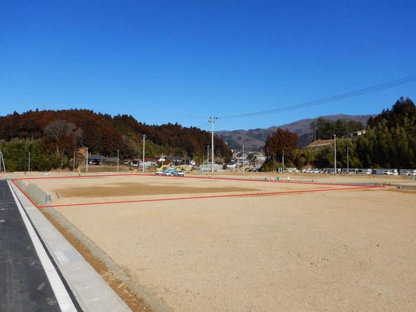
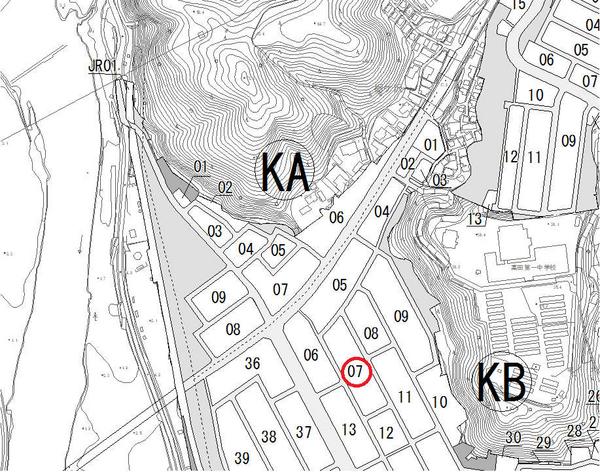
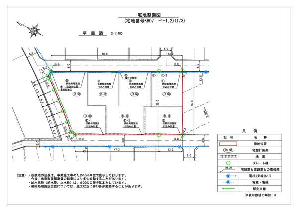
Located in Takata-cho, Rikuzentakata City, Iwate Prefecture, this expansive 2,489-square-meter plot of land represents a prime development opportunity in an area undergoing active land readjustment. The property is currently designated as a temporary reallocation site in the KA07 block (plots 1-1,-2).

Situated in a Type 1 residential zone with a building coverage ratio of 60% and a floor area ratio of 200%, this vacant lot offers flexible development possibilities. The property benefits from its location in an area that's seeing significant post-tsunami reconstruction efforts, including new seawalls and elevated land development.

The land is conveniently accessible from the Rikuzentakata Station on the JR Ofunato Line (BRT). The area is known for its relatively mild climate throughout the year and is close to local landmarks such as the Miracle Pine Tree and the Takata-Matsubara Road Station. Both purchase and lease options are available for this property.

This description was AI-generated from the original Japanese listing and may contain inaccuracies. Please verify details with the source listing.

Summary

Land size: 2,489 / 26,792sqft

Short-Term Rental (Minpaku)

Transport

NRT

Narita International Airport — 377 km away

Nearby Konbini

Family Mart Family Mart — 18 min walk

Internet Connectivity

Natural Hazard Assessment

Flood Risk Low Risk
Landslide Risk Moderate
Tsunami Risk Low Risk
Earthquake Hazard Moderate

Unlock hazard data with a free trial

Flood, landslide, tsunami & earthquake risk for this property

3 days free · cancel anytime

Start Free Trial

Purchase Cost & Tax Estimates

Agent fees, acquisition tax, registration costs & annual property tax

Map & Street View

Map loading...

Location Accuracy Notice: Although we try to make the map accurate with coordinates or address details provided, the location data is provided by the agent. This map data should be used as reference for the surrounding area foremost.

Location Type Beds Price Land House View

* Sold properties shown for price comparison only. Prices reflect historical sale data.

Location Type Beds Rent/Month Land House View

* Rental prices shown are monthly rates. Contact property owner for current availability.