Back to results 143m2 Building Plot in Matsunami-Aoba, Moriya City
Added 2 days ago

Know someone who would love this? Gift them a subscription

¥28,000,000

Matsunami-Aoba 3, Moriya City, Ibaraki Prefecture

茨城県守谷市松並青葉3

Sign in to save properties

Work with our partners to help you search, evaluate, and purchase property in Japan.

Book a Consultation
Buy Land Parking Suburban Near Shopping Quiet Area

Unlock the full description with a free trial

Includes AI translation, hazard data, cost estimates & nearby amenities

3 days free · cancel anytime

Start Free Trial

Building Plot in Matsunami-Aoba, Moriya City

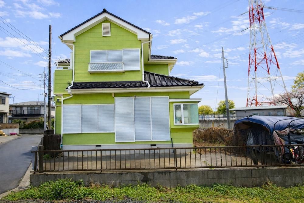
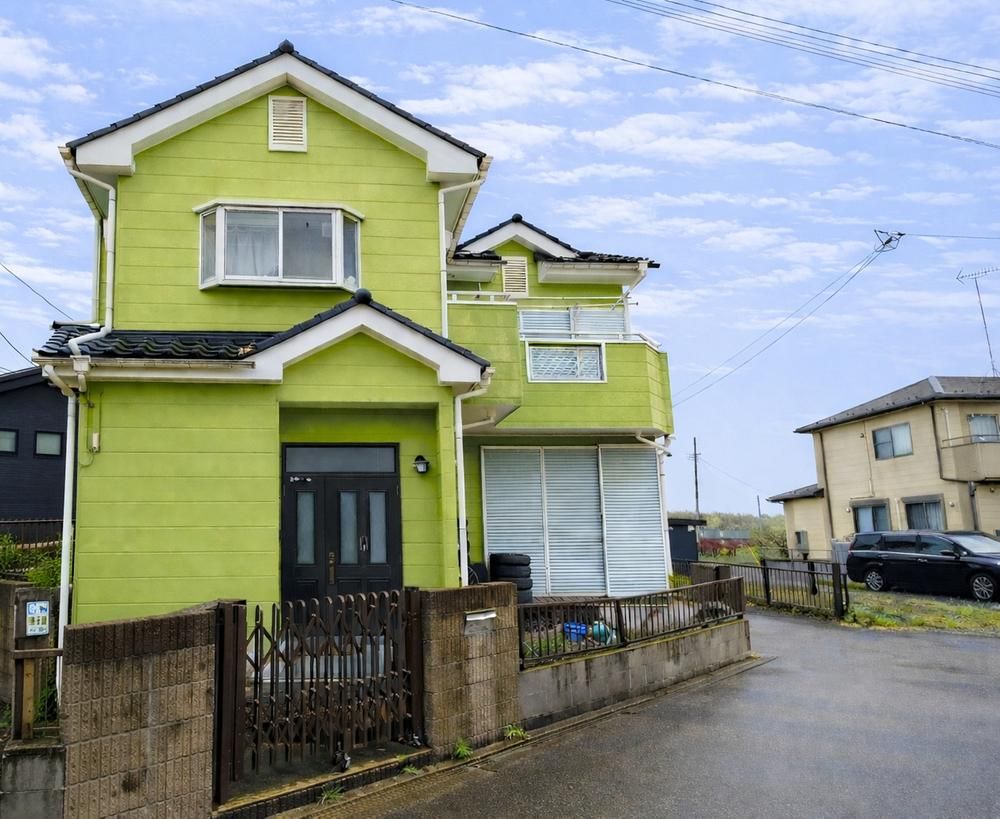
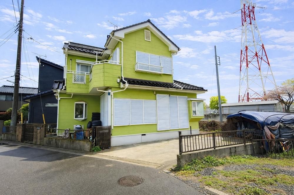
This is a building plot located in the popular Matsunami-Aoba area of Moriya City, Ibaraki Prefecture. The land is priced at 28,000,000 JPY and has a land area of 143.34 square meters (approx. 43.36 tsubo). The property faces a 4-meter wide public road to the southwest, providing good sunlight exposure. There is no building condition attached, allowing you the freedom to choose your own builder. The site is currently occupied by an old house, scheduled for demolition by the end of June 2026 (Reiwa 8), after which it will be delivered as cleared land. The property is located a 19-minute walk from Moriya Station on the Tsukuba Express line and an 18-minute walk from Shin-Moriya Station on the Kanto Railway Joso Line, offering convenient access to two railway lines. The neighborhood features a row of pine trees, parks, and nearby shopping facilities, creating a pleasant living environment. Nearby amenities include Yorktown Moriya shopping center (10 min walk), Kawachi Moriya Matsunami drugstore (9 min walk), Foodwarehouse Branch Moriya supermarket (17 min walk), Lawson Tsukubamirai Tsutsudo convenience store (7 min walk), Moriya City Kurochi Elementary School (18 min walk), Moriya City Moriya Junior High School (27 min walk), Moriri Nursery School (9 min walk), and Matsunami-Aoba Nozomi Nursery School (9 min walk). Parks such as Amanogawa Park (5 min walk) and Hoshi no Hiroba (8 min walk) are also nearby. The property is located in a urbanization control area and requires a building permit. It has access to public water mains and a public sewage system. The building coverage ratio is 60% and the floor area ratio is 160%. The land is zoned as a residential site. This information will be automatically reflected in other inquiries (discarded after 30 minutes).

This description was AI-generated from the original Japanese listing and may contain inaccuracies. Please verify details with the source listing.

Summary

Land size: 143 / 1,543sqft

Short-Term Rental (Minpaku)

Transport

NRT

Narita International Airport — 42 km away

Nearby Konbini

Family Mart Family Mart — 10 min walk

Internet Connectivity

Natural Hazard Assessment

Flood Risk Low Risk
Landslide Risk Moderate
Tsunami Risk Low Risk
Earthquake Hazard Moderate

Unlock hazard data with a free trial

Flood, landslide, tsunami & earthquake risk for this property

3 days free · cancel anytime

Start Free Trial

Purchase Cost & Tax Estimates

Agent fees, acquisition tax, registration costs & annual property tax

Airbnb Revenue Estimate

Projected nightly rate, occupancy & net income for this property

Investment ROI

Annual yield, break-even timeline & 10-year return projection

Map & Street View

Map loading...

Location Accuracy Notice: Although we try to make the map accurate with coordinates or address details provided, the location data is provided by the agent. This map data should be used as reference for the surrounding area foremost.

Location Type Beds Price Land House View

* Sold properties shown for price comparison only. Prices reflect historical sale data.

Location Type Beds Rent/Month Land House View

* Rental prices shown are monthly rates. Contact property owner for current availability.