Back to results Vacant Land for Sale in Sakyo Ward, Kyoto - 167.39 sqm

Verified Listing

This property was checked recently and confirmed to still be available. Tap for details.

Verified Listing

This property has been verified in the last month. Our system regularly checks listings to ensure they are still available.

Last verified: April 22, 2026

Know someone who would love this? Gift them a subscription

¥58,800,000

Iwakura Kita Kuwabara-cho, Sakyo Ward, Kyoto City, Kyoto Prefecture

京都府京都市左京区岩倉北桑原町

Sign in to save properties

Buy Near Station Land Suburban Quiet Area

Unlock the full description with a free trial

Includes AI translation, hazard data, cost estimates & nearby amenities

3 days free · cancel anytime

Start Free Trial

Land for Sale in Kyoto's Left Bank District

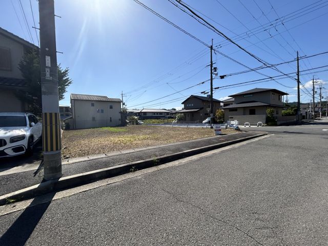
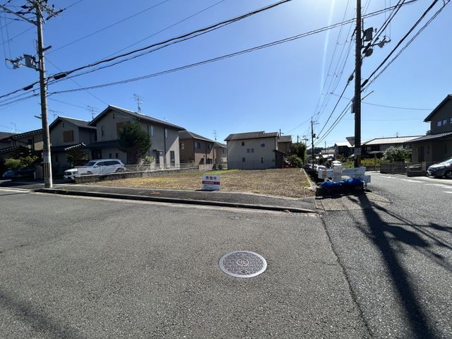
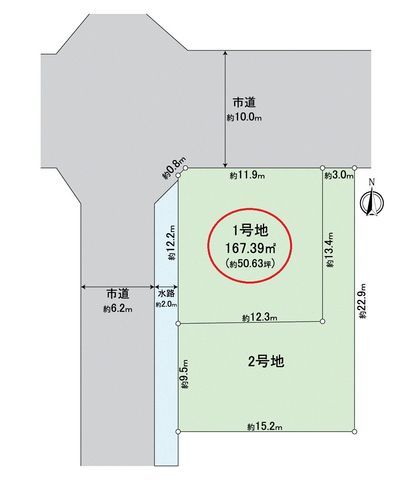
This vacant land plot is located in Kyoto's Left Bank (Sakyo Ward), offering a flat building site in a quiet residential area. The property has a total land area of 167.39 square meters (approximately 50.63 tsubo) with a frontage of 11.9 meters facing a 10-meter wide public road to the north. The site is designated as a Category I Low-Rise Exclusive Residential Zone, with a building coverage ratio of 40% and a floor area ratio of 60%. There are no specific building conditions attached to the land.

The property's current status is vacant land. The agent's special notes state: "Vacant land. If you would like to see it in person for free, please feel free to contact us with your preferred date."

The location provides convenient access to daily amenities. A Life supermarket is a 7-minute walk (540m) away, a Drug Utaka pharmacy is a 2-minute walk (140m), and a 7-Eleven convenience store is a 5-minute walk (370m). For families, Kyoto Municipal Iwakura Minami Elementary School is a 4-minute walk (280m), and Rakuhoku Junior High School is a 10-minute walk (770m).

Transportation access is available via two train stations. Kyoto Municipal Karasuma Line's Kokusai Kaikan Station is an 8-minute walk, and the Eizan Dentetsu Kurama Line's Iwakura Station is a 9-minute walk. The property is connected to public water supply and city gas infrastructure.

This description was AI-generated from the original Japanese listing and may contain inaccuracies. Please verify details with the source listing.

Summary

Land size: 167 / 1,802sqft

Short-Term Rental (Minpaku)

Transport

ITM

Osaka International Airport — 44 km away

Nearest Konbini

circle_k Circle K — 3 min walk

Internet Connectivity

Natural Hazard Assessment

Flood Risk Low Risk
Landslide Risk Moderate
Tsunami Risk Low Risk
Earthquake Hazard Moderate

Unlock hazard data with a free trial

Flood, landslide, tsunami & earthquake risk for this property

3 days free · cancel anytime

Start Free Trial

Purchase Cost & Tax Estimates

Agent fees, acquisition tax, registration costs & annual property tax

Airbnb Revenue Estimate

Projected nightly rate, occupancy & net income for this property

Investment ROI

Annual yield, break-even timeline & 10-year return projection

Map & Street View

Map loading...

Location Accuracy Notice: Although we try to make the map accurate with coordinates or address details provided, the location data is provided by the agent. This map data should be used as reference for the surrounding area foremost.

Location Type Beds Price Land House View

* Sold properties shown for price comparison only. Prices reflect historical sale data.

Location Type Beds Rent/Month Land House View

* Rental prices shown are monthly rates. Contact property owner for current availability.